
Machu Picchu: The astonishing genius of Incan architecture, engineering, and spirituality
Machu Picchu rises above the cloud-wrapped ridge between Huayna Picchu and the Urubamba River and largely reveals the intellectual goals of the Inca Empire during a period of rapid expansion under Pachacuti Inca Yupanqui.
It had likely been constructed around 1450 and had been abandoned before Spanish forces advanced into the region, and the site had stayed hidden from colonial damage and written records.
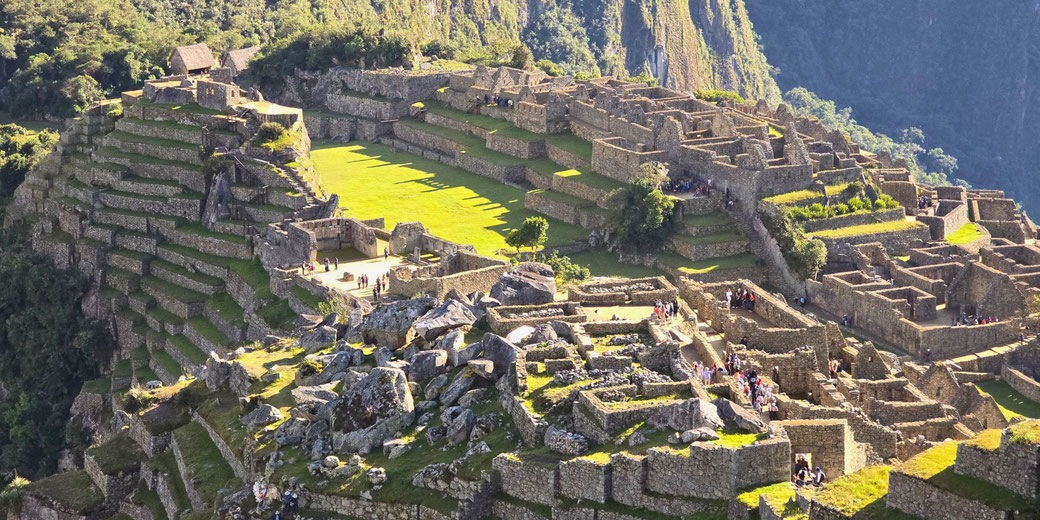
After its rediscovery in 1911, Machu Picchu soon became a major focus of international archaeological investigation because of its striking location, as its stonework showed skilled workmanship, and because its infrastructure managed water and terraces through careful engineering that included cosmological symbols in its design.
The imposing location of the city
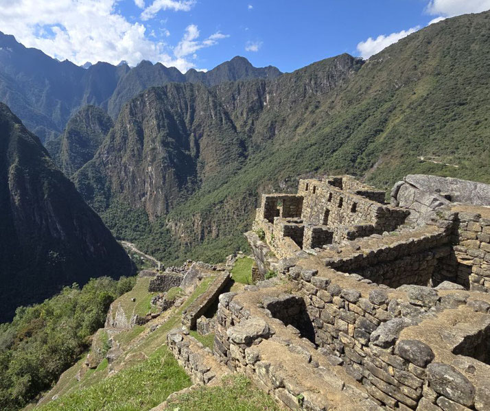
Machu Picchu is positioned at roughly 2,430 metres above sea level, on a narrow saddle of land framed by two mountain peaks and surrounded by steep cliffs that drop into the deep bend of the Urubamba River far below.
From this remote perch, the city offered clear views across a broad area that the Inca considered sacred, where every mountain peak had a spiritual significance as an apu, or protective deity of the natural world.
For this reason, planners selected a site that allowed for direct visual connection with several of the most important peaks, including Salkantay and Veronica.
The elevation reinforced the Inca’s belief that high places brought them closer to celestial forces and allowed rituals to occur in proximity to both the heavens and the earth.
Instead of reshaping the terrain to suit an urban plan, Inca builders generally allowed the mountain’s contours to guide the placement of structures.
As a result, buildings, plazas, and terraces followed the natural gradient, which created a natural connection between human spaces and sacred places.
A brief history of Machu Picchu
Evidence from ceramic fragments, architectural styles, and radiocarbon dating firmly suggests that construction began during the reign of Pachacuti, who ruled from approximately 1438 to 1471.
He had led the transformation of Cusco from a regional power into the centre of a continental empire.
During this campaign of expansion, Pachacuti commissioned ceremonial sites, roads, and administrative centres that particularly expanded imperial control across newly conquered regions.
Other projects, such as the grand terraces of Ollantaytambo and the Qorikancha temple in Cusco, is evidence of his desire to change the physical and spiritual world of the Andes.
In this imperial framework, Machu Picchu likely primarily operated as a royal estate used seasonally by the emperor and his court for religious ceremonies and ritual performance, providing spaces where the court could rest during seasonal visits.
Unlike cities designed for permanent residence, Machu Picchu lacked large-scale markets or production facilities, which indicates its specialised use related to status and ceremonies.
A few scholars have suggested alternative theories, including the possibility that the site served as a pilgrimage destination or an astronomical observatory.
Excavations had revealed distinct urban areas where priests, artisans, retainers, and administrators had typically lived close to temples, fountains, and shrines.
Below the main group of structures, stepped agricultural terraces supplied food to the resident population, although the layout suggests that additional provisions would have arrived from the Sacred Valley.
Archaeologists estimate that between 300 and 750 people probably lived there at any one time, depending on the season and ceremonial calendar.
After the collapse of central authority following the Spanish conquest in the 1530s, Machu Picchu was abandoned.
No written sources from the period mention it, and because the remote terrain likely discouraged Spanish military or religious expansion into the area, the city probably avoided destruction, looting, or religious repurposing, which kept its structures intact for centuries.
The incredible engineering skills used in its construction
Inca masons typically constructed the site using ashlar techniques in which they cut granite blocks so that they fitted perfectly without mortar and stood up to earthquakes without needing later repairs.
As the Andes lie along fault lines, earthquakes posed a constant threat, and engineers responded to this when they cut irregular stones into interlocking patterns that spread forces through the structure.
Similar methods appear in the foundations of Sacsayhuamán. To preserve the site on steep and unstable terrain, workers built extensive foundations beneath visible walls.
Layers of stone chips, gravel, and sand were arranged beneath walkways and plazas, which allowed water to drain quickly and prevented collapse due to shifting soils.
More than half of the site's work had largely lain beneath the surface, where key support systems had been hidden but remained vital.
In addition, engineers developed a carefully planned water management system that typically included carved drainage canals, ceremonial fountains, and concealed channels, which diverted rainfall from the mountain into controlled outlets.
Rainwater passed first through sacred courtyards before reaching the lower terraces, where it watered crops and then flowed down the mountain.
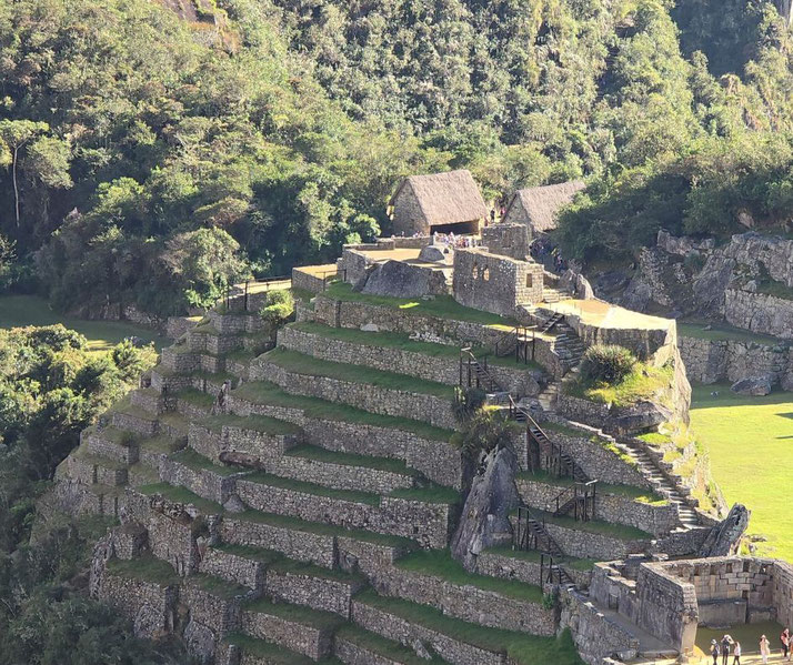
To increase usable land, builders carved terraces into the mountainside mainly to create flat areas for cultivation and to reduce erosion.
Each terrace included layers of gravel and soil that filtered water and stabilised the ground.
As mentioned above, Machu Picchu had more than 700 terraces, some of which near ceremonial structures sometimes served a decorative purpose within the spiritual setting.
Movement between zones generally followed a clear plan, as staircases cut directly into bedrock connected different levels, while trapezoidal doorways managed movement between residential, agricultural, and ceremonial spaces.
This arrangement supported social hierarchy and the order of rituals, as people moved through the site according to status and role.
How the ruins of Machu Picchu were found
On 24 July 1911, Hiram Bingham, who was an American historian sponsored by Yale University and the National Geographic Society, reached Machu Picchu with the guidance of local Quechua-speaking farmers who already knew of the site's location.
His expedition had originally searched for Vilcabamba, the last refuge of the Inca resistance, but the discovery of a different kind of site shifted the focus of his work entirely.
Soon after, Bingham led further expeditions that documented and excavated key parts of the city, and as a result, among the items uncovered were fine pottery, bronze tools, burial remains, and architectural elements.
However, Bingham also removed hundreds of artefacts to the United States and placed them in Yale University's Peabody Museum, which later became the focus of a long dispute with the Peruvian government over the rightful location of the artefacts.
Eventually, Peru secured the return of many of these items, especially after long negotiations in the early 2000s.
The episode drew attention to both the significance of the site and the responsibilities of archaeological institutions in managing cultural heritage.
In recognition of its importance, UNESCO granted World Heritage status to Machu Picchu in 1983.
Since then, Peruvian authorities and international organisations have worked to regulate tourism, prevent damage to structures, and carry out further research into the site's design and symbolic meaning.
Visitor numbers are now capped at 3,800 people per day, with timed entry tickets introduced in 2019 to reduce crowding and protect fragile pathways.
The mystical elements of Machu Picchu's design
Astronomical alignment affected several of Machu Picchu's main features, as the Temple of the Sun was built on a curved stone foundation and includes windows aligned to direct sunlight onto key interior stones during solstices.
This likely allowed priests to mark the passage of time and show when to perform important farming and religious ceremonies.
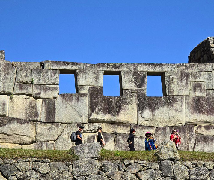
Nearby, the Temple of the Three Windows and the Principal Temple also feature prominently in the ceremonial heart of the city.
Another significant structure was the Intihuatana, which archaeologists interpret as a solar gnomon.
Its carved angles and placement suggest that it was used to track seasonal shifts and regulate the ceremonial calendar, and as the Inca linked political authority with the movement of celestial bodies, such instruments formed part of a wider ritual system that supported imperial authority.
Sacred geometry shaped the appearance of doorways, niches, and windows, which provided both structural strength and a consistent look, while possibly reflecting the Incan division of the world into three linked worlds: hanan pacha (upper world), kay pacha (earthly world), and uku pacha (underworld).
Builders also preserved natural outcrops and left them partially exposed inside temples or ceremonial courtyards.
These rocks, which were sometimes carved or ornamented, were used as huacas: objects thought to hold spiritual power.
Modern LIDAR surveys have revealed more huacas and ceremonial alignments once hidden under overgrowth.
Today, visitors often describe a sense of awe as they enter the site because of its dramatic setting and the silent dialogue between stone and sky, geometry and spirit.
Machu Picchu was both an impressive engineering achievement and a monument to a way of seeing the world that showed reverence for nature through imperial authority and sacred practice.
For many modern Quechua communities, it continues to hold ongoing cultural and spiritual importance as a living connection to their ancestral heritage.