9 engineering marvels of the Inca Empire

Tucked high into the mountains of the Andes, the Inca Empire constructed architectural features and infrastructure that still defy many of our modern expectations.
By the fifteenth century, engineers across the empire had created long-lasting stonework, combined water systems and an extensive road network, despite lacking iron tools, wheeled transport, or large draft animals.
Step by step, they adapted their methods to extreme terrain, which produced a record of practical solutions that used local materials, communal labour under the mit’a system, and a clear understanding of how structures carried loads and how materials resisted stress.
The difficult environmental conditions of the empire
In the Andean highlands, Inca engineers faced persistent geographic and climate challenges.
From steep mountain slopes to earthquake risk, the terrain tested every design.
Most settlements sat above 2,500 metres, and many settlements, such as Cusco, exceeded 3,400 metres.
At these altitudes, oxygen levels remained low, and daily temperature shifts brought heat and frost within hours.
Also, rainfall, snowmelt, drought, and erosion presented additional threats that required specific responses in every region.
Often, the ground itself proved unstable due to volcanic activity and frequent earthquakes, so engineers could not rely on standard foundations and instead developed methods that allowed walls and platforms to flex and absorb movement without collapsing.
They embedded structures into hillsides rather than flattening the terrain, and they used the land for support.
In areas with heavy rainfall, they included underground drainage and water diversion systems that protected structures from water damage.
Eventually, a civil engineering tradition developed that favoured working with the environment and long-term durability.
In particular, they used available materials such as andesite, granite and adobe, which they worked with stone, bronze and wooden tools.
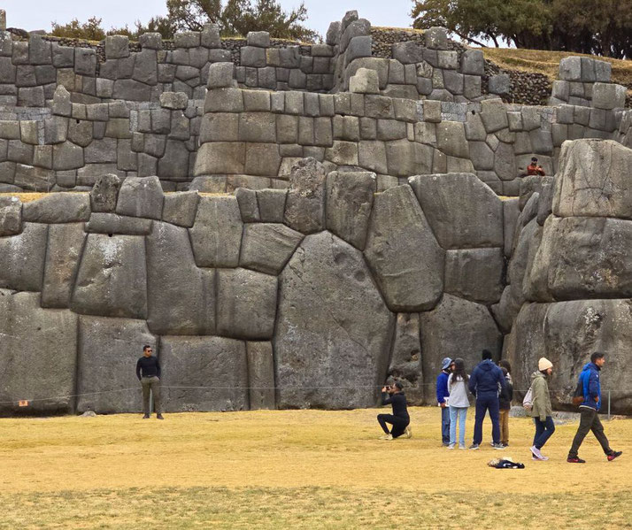
1. Saksaywaman
Located on a hill overlooking Cusco, Saksaywaman worked as both a ceremonial centre and a military fortress.
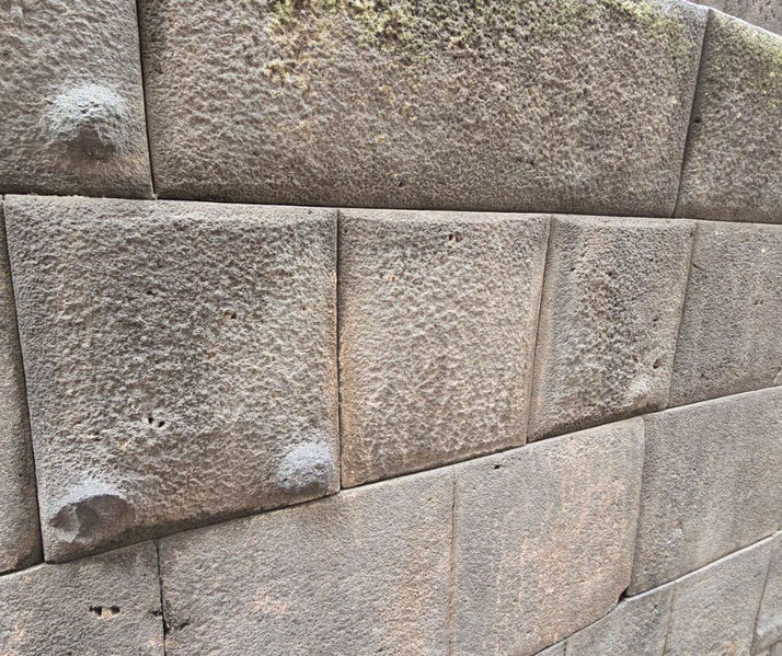
Its defining feature included three concentric zigzag walls built from enormous andesite stones, some of which are estimated to have weighed over 100 tonnes.
They were cut with such accuracy that mortar became unnecessary, and the stones interlocked in ways that kept the walls standing even during earthquakes.
By design, the layout followed the contours of the hill, which provided both visual prominence over the capital and added seismic resistance.
Chroniclers such as Garcilaso de la Vega recorded that tens of thousands of workers had reportedly completed the site under state labour obligations.
Inca workers moved the stones without wheeled carts or cranes, most likely by dragging them up prepared ramps using manpower and coordination.
The fortress walls may have taken the form of the teeth of a puma, which was how Cusco itself was traditionally believed to have been laid out in the shape of that sacred animal.
During festivals such as Inti Raymi, large gatherings assembled at the site for ritual celebrations, and its scale reinforced the sacred authority of the Sapa Inca.
After the Spanish had arrived, they dismantled large portions of the upper walls, reusing the stones in Cusco’s colonial buildings.
Still, the lower courses are largely intact and continue to show how large the constructions were and how precisely the stones fitted together to meet both practical needs and ritual uses.
2. Machu Picchu
Perched on a mountain ridge nearly 2,500 metres above the Urubamba River, Machu Picchu is believed to have been a royal estate, religious retreat, or possible astronomical observatory.
Commissioned by Pachacuti in the mid-fifteenth century, the city featured more than 200 buildings, including temples, residences, ritual platforms, and storage houses.
Each structure followed a layout adapted to the terrain, which sloped sharply downward on both sides.
Importantly, engineers developed an underground system of retaining walls and channels that helped remove excess water and reduced build-up and soil erosion during heavy rains.
They used ashlar masonry, which involved cutting blocks of granite so finely that they locked together and needed no cement.
The agricultural terraces along the city’s edge helped provide food and slope stability, helping to prevent landslides.
Because of its remote location and careful design, the site remained hidden during the Spanish conquest and survived intact.
This is, until Hiram Bingham brought it to international attention in 1911 after local Quechua-speaking farmers had guided him to the site, and in 1983, UNESCO listed it as a World Heritage Site.
Today, its spiritual associations and architectural elegance complemented sound engineering, which continued to draw admiration.

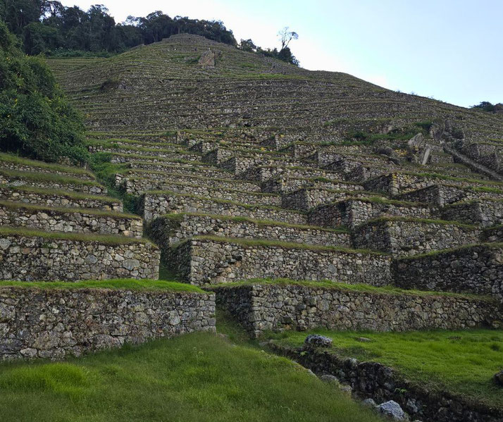
3. Ollantaytambo
At the junction of the Patakancha and the Urubamba rivers, Ollantaytambo was a fortress, royal estate, and administrative centre that also defended the Sacred Valley.
Its construction included monumental terraces, long staircases, and religious buildings arranged along the slopes of a steep mountain.
Most impressively, engineers built the Temple Hill group of structures from large pink rhyolite blocks that are thought to have been quarried on the opposite side of the valley.
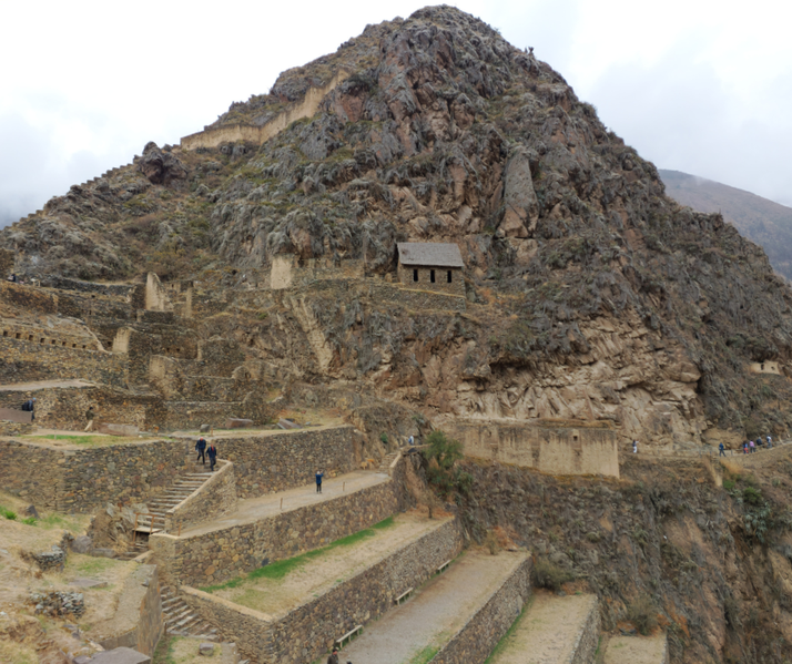
To move the stones across the river and up the slope, Inca labourers likely used log rollers, earth ramps, and coordinated teams.
Alongside the temple, canals and aqueducts channelled mountain water into fountains and agricultural fields, which likely showed both practical management and ritual significance.
The unfinished Temple of the Sun suggests that construction halted during the Spanish invasion, though it is also possible that shifting priorities or internal disruption caused the work to stop.
While the Spanish had captured most Inca sites quickly, Ollantaytambo briefly resisted, and Manco Inca used its defences to hold off attackers in 1537.
Even unfinished, the scale and scope of its construction continued to display the state’s engineering vision.
4. Inca road system (Qhapaq Ñan)
Across deserts, mountains, valleys, and rainforests, the Inca road system known as the Qhapaq Ñan extended up to 40,000 kilometres.
It connected administrative centres, military outposts, storage facilities, and religious shrines across the empire, and allowed the movement of goods, armies, and information.
At its heart, the main route ran north to south from Quito to Cusco and continued down to Chile and Argentina.
Today, remnants of the system stretch across six modern countries.
Engineers adapted each segment of road to suit the local environment: on flat land, they paved the roads with fitted stones, while in marshes, they raised causeways on earthen embankments.
In mountainous regions, they carved steps and switchbacks directly into the rock.
At regular intervals, tambos worked as rest stations, which were stocked with supplies and food, which were placed at roughly 20-kilometre intervals to support messengers and officials.
Chasquis were messengers who ran in relay along these roads and may have used quipus to carry encoded information, as suggested by Spanish accounts.
Despite lacking wheels or horses, the road system helped ensure a level of coordination and speed that allowed the Inca state to manage far-flung provinces with efficiency.
5. Suspension bridges
Where deep gorges and fast rivers cut across the road system, Inca engineers built rope suspension bridges using grass fibre and woven reed cords.
Anchored to stone piers on either side of the ravine, the bridges included two main ropes for support, a walking surface, and handrails that stabilised movement.
Some bridges spanned distances of over 30 metres and were often the only reliable crossings for entire regions.
Each year, local communities dismantled and rebuilt the bridges using traditional methods, so dozens of villagers harvested ichu grass, twisted it into cables, and braided them into large ropes.
They worked together to suspend the ropes over the gap, tightened them, and constructed the walking deck with woven matting.
Typically, the bridges lasted one to two years before they required full replacement.
The Q’eswachaka Bridge, which is still maintained today in this way by communities in Canas Province and which had been inscribed on UNESCO’s Intangible Cultural Heritage list in 2013.
The bridges relied on flexible construction and careful adjustment of tension to maintain balance across the span, and they carried people and animals safely across dangerous rivers and ravines.
6. Adaptable terracing
On steep hillsides across the Andes, the Incas created stepped terraces, known as andenes, which converted unstable slopes into productive farmland.
Each terrace included a retaining wall, layered fill, and a surface of fertile soil. This design prevented landslides, conserved water, and allowed cultivation where flat fields did not exist.
To construct the terraces, engineers layered large stones for drainage, followed by gravel and sand to regulate moisture, and topped it with rich soil, so crops such as potatoes, oca, quinoa, and maize grew well in these microclimates, and the arrangement of the terraces helped control solar exposure and airflow.
Often, they oriented the fields to capture morning sunlight and shed water efficiently.
Archaeobotanical evidence supports the diversity of crops grown across an area estimated at over a million hectares of terraced land.
In addition to food production, some terrace systems carried ceremonial or experimental purposes, especially near royal estates.
In each case, they showed how the Incas applied detailed observation to engineer sustainable agricultural systems that matched the needs of different altitudes.
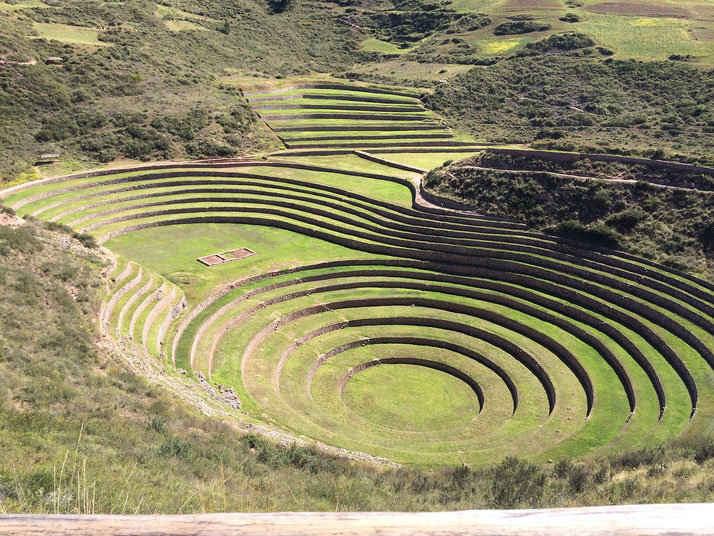
7. Moray
Northwest of Cusco, the site of Moray used circular depressions and concentric terraces to create a climate-controlled agricultural laboratory.
Engineers designed it so that temperature, sunlight, wind, and humidity varied slightly from level to level, which allowed them to simulate growing conditions from across the empire.
This variation could reach as much as 15°C between the top and bottom terraces.
Water entered the system from springs, and the terraces tended to drain effectively due to layers of porous material beneath each level.
The deepest depressions measured at around 30 metres from rim to floor. It is likely that Moray allowed Inca agronomists to adapt crops for unfamiliar climates, which enabled tests of seed performance across micro-zones and so quinoa, maize, and other key crops could be trialled and altered for maximum yield.
Some scholars believe the site aligned with solar movements and allowed for seasonal observations.
Terraces were not used only to grow food, and the Incas used them to experiment with crop evolution and suitability.
This foresight supported agricultural success across the ecological diversity of the Andes.
8. Tipón
Built into a steep valley south of Cusco, Tipón showed the careful engineering of Inca hydraulic systems.
Water from a high-altitude spring descended through canals, fountains, and terraced fields, which spread moisture evenly across the site.
Engineers used carved stone channels to guide the water so that it flowed steadily down controlled gradients and reached ceremonial and agricultural features in a clear, organised way.
Tipón combined irrigation with religious symbolism and had both practical and sacred roles, though its association with Inca Wiracocha is uncertain.
Its fountains and aqueducts may have been used in purification rituals, and its layout reflected a controlled relationship between people, water, and land.
Terraces on the hillsides received irrigation water in sequence, which allowed fields to remain fertile regardless of seasonal rainfall.
The ability to adjust water flow using gates and diverters has shown a high level of hydraulic knowledge, so, even now, modern irrigation specialists study Tipón for its design efficiency and environmental suitability.
The main canal still operates and generally delivers water with remarkable consistency.
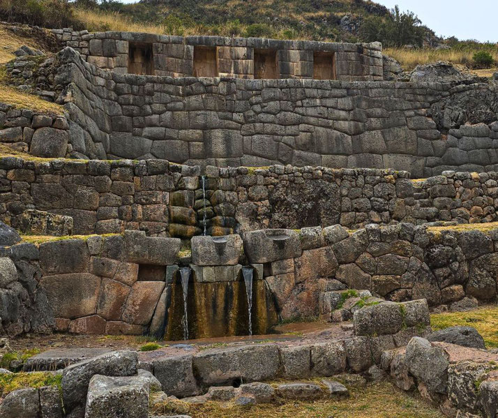
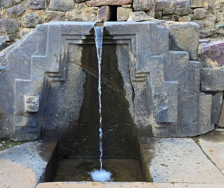
9. Tambomachay
Finally, near the outskirts of Cusco, Tambomachay offered a sanctuary built around water flow and for ritual use.
The site contained a series of fountains and channels carved into finely fitted stonework, and engineers directed natural spring water into twin streams that emerged simultaneously from hidden spouts.
These symmetrical flows symbolised sacred order and ritual purity, and likely reinforced methods of controlled water use during royal or priestly ceremonies.
Unlike agricultural sites, Tambomachay focused entirely on the sacred value of water.
The design included terraces, walls, and concealed pipelines that maintained pressure and clarity across multiple levels.
Visitors would likely have approached the site from the Inca road and undergone ritual purification before major events or seasonal ceremonies, and some scholars argue that Tambomachay worked as a royal bathing area or a military outpost.
Quiet cascades and perfectly measured fountains at Tambomachay presented an Inca view that water deserved reverence, and that true power included the ability to tame and honour the natural world.