
Hadrian's Wall: the mysterious ruins that hold secrets of Roman Britain
Across the worn hills and moors of northern England, a line of ancient stone stretches from coast to coast and cuts across the countryside.
Built in AD 122, probably under the orders of Emperor Hadrian, the wall formed the northernmost limit of Roman imperial control in Britain and became a permanent feature of Rome’s frontier policy.
Nearly two thousand years later, its ruins continue to show how the empire responded to threats, set military objectives, and organised frontier defence as it reached into unfamiliar lands and tried to hold them with sustained force.
Brief history of the wall
No ancient source confirms Hadrian’s personal presence in Britannia, but officials likely ordered construction as part of his wider imperial reforms.
Roman control had previously pushed somewhat further north, but supply problems, military strain, and ongoing resistance made further expansion unsustainable.
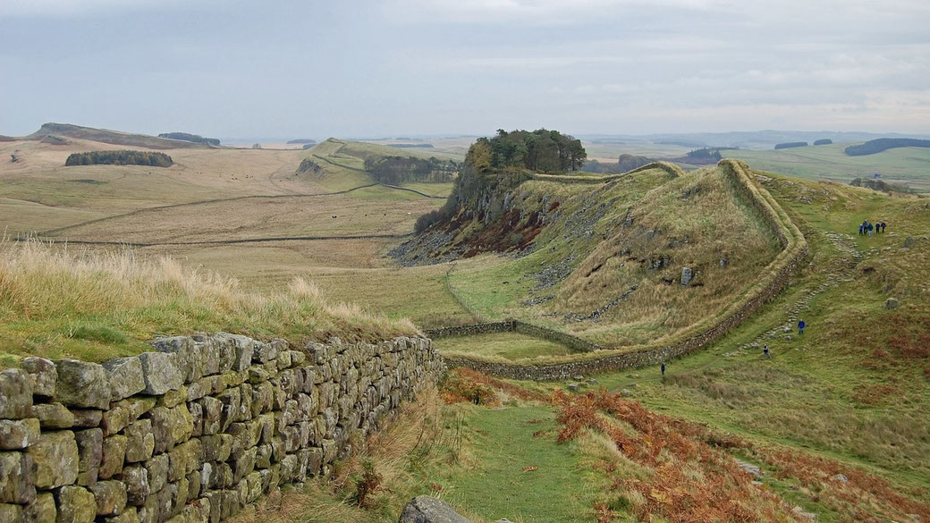
As a result, Roman engineers designed a fixed defensive line that ran roughly 117 kilometres from the River Tyne in the east to the Solway Firth in the west.
Construction began around AD 122 and progressed over several years. By AD 128, major building phases appeared to have been completed, and improvements and additions continued for decades afterwards.
Initially, the wall consisted of a stone wall up to 3 metres wide and likely between 4 and 5 metres high in its eastern section, while a narrower turf wall appeared in the western stretch due to limited local stone.
The entire structure incorporated a wide ditch on the northern side, a road for military use to the south, and a system of milecastles, watchtowers, and large forts spaced regularly along its length.
Each part supported wider aims by allowing regular patrols, by administering local garrisons, and by regulating the movement of people and goods along the frontier.
Roman planning ensured that construction progressed rapidly, and by AD 128 the wall had become an operational frontier that included permanent garrisons, supply depots, and civilian settlements.
Estimates suggested that perhaps over 15,000 soldiers had participated in its construction and that they had included both legionaries and auxiliaries and had used local resources and had followed standard designs.
Later, under Antoninus Pius, Roman forces constructed a second wall further north between the Firth of Forth and the Firth of Clyde.
However, within two decades, the Antonine Wall proved unsustainable, and Roman troops returned to Hadrian’s Wall.
The Antonine Wall, though more northerly, was shorter and constructed largely of turf; its abandonment by around AD 158 likely stemmed from supply issues and increasing hostility from Caledonian tribes.
From the mid-second century to the early fifth century, the line generally remained the empire’s main boundary in Britain.
Imperial authority weakened and Rome’s ability to project power into the provinces declined.
Who physically built it?
Roman legions carried out the initial construction work under direct imperial command, with Legio II Augusta, Legio VI Victrix, and Legio XX Valeria Victrix recorded in inscriptions carved into stones placed along the wall.
These inscriptions typically identified the unit, the cohort, and sometimes the officer who supervised a section’s completion.
Some inscriptions have been linked to auxiliary units such as the cohors I Dacorum, though its presence is better documented in later periods and at sites away from Milecastle 38.
In some cases, the stones included decorative designs or dedications to imperial authority.
Specifically, engineers planned the layout in standardised units, but difficult terrain required adjustments as the line crossed crags, rivers, and ridges.
After construction had ended, Rome deployed auxiliary units to occupy the forts and patrol the frontier.
These troops came from provinces, and they did not initially hold Roman citizenship, which made them unlike legionaries.
Many were cavalry or light infantry recruited for their ability to move and familiarity with rough terrain.
Cohorts stationed along the wall included men from Gaul, Thrace, Batavia, and Syria, whose presence brought different cultures to the region.
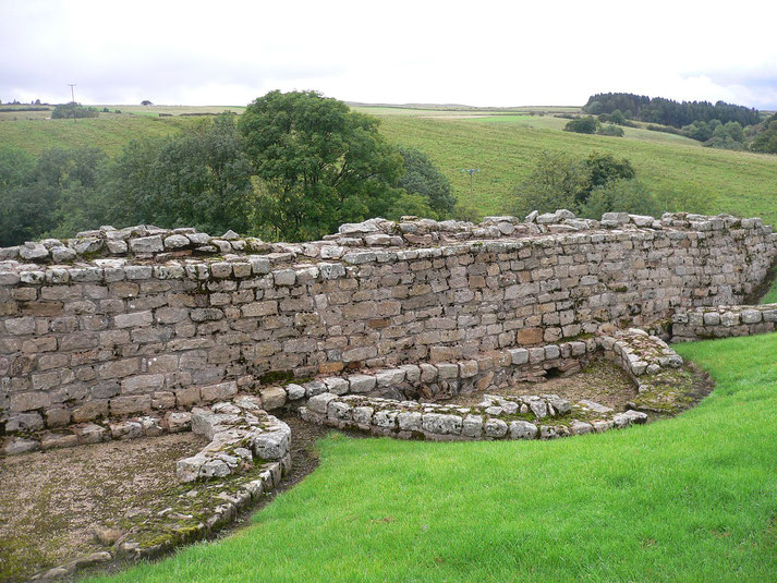
Garrison towns such as Housesteads (Vercovicium), Chesters (Cilurnum), and Birdoswald (Banna) supported military operations and provided facilities such as bathhouses, granaries, workshops, and temples.
Civilians also contributed to the daily life and maintenance of the frontier, as craftspeople, merchants, and local Britons settled in the vici that developed outside the forts and supplied goods, services, and labour.
Over time, some adopted Roman customs, although the military maintained strict control of movement across the wall and limited local access to imperial authority.
Historians estimate that perhaps up to 10,000 soldiers and several thousand civilians lived and worked in the immediate vicinity of the wall at its peak.
Roman citizenship was often awarded after years of service and remained an incentive for auxiliaries and a barrier between ruling elites and subject peoples.
Fatal flaws
From a structural perspective, the wall lacked the ability to form a completely sealed frontier.
Its length, terrain, and wide spacing between milecastles created gaps that small raiding parties could exploit, especially during periods of poor visibility or low garrison strength.
Patrols operated along the military road that ran parallel to the wall. Modern studies often call this road the Military Way, which was not its Roman name.
The wall worked more as a regulated checkpoint system than an uninterrupted barrier.
Even during peacetime, movement across the frontier continued under watch, with traders, envoys, and migrants interacting with Roman forces.
The supply burden of supporting the wall’s garrisons placed heavy demands on the empire, particularly during periods of crisis.
The supply of food, equipment, and replacements for troops stationed in remote and often inhospitable conditions required a dependable network of roads, depots, and civilian contractors.
During the third century, when civil wars and external invasions drew attention away from the provinces, the wall had received less reinforcement.
As a result, it had become vulnerable to both external attack and internal discontent.
In AD 180, a major attack by northern tribes is reported to have breached the wall’s defences and killed Roman officers. The identity of the governor involved remains uncertain.
Hadrian’s decision to abandon further expansion in Britain and instead construct a permanent barrier probably changed how Rome interacted with northern tribes.
Earlier governors had promised benefits to allied groups in exchange for cooperation, but the creation of a hardened border shifted relationships from negotiation to exclusion.
Over time, some groups who had once been willing to accommodate Roman presence began to resist more forcefully, and raids became more frequent.
As the frontier grew less porous, resentment hardened, and Rome’s diplomatic options narrowed.
Important archaeological discoveries
Excavations at Vindolanda, which lay just south of the main wall, uncovered a large collection of wooden tablets that were preserved in oxygen-poor soil.
The Vindolanda tablets, which had been written in ink and which dated from approximately AD 85 to 130, included personal letters, duty rosters, supply requests, and administrative records.
One of the most well-known examples is a birthday invitation sent by Claudia Severa to Sulpicia Lepidina, written in a confident Latin hand.
Its tone shows personal connections between officers’ families and the presence of educated women and organised social life on the frontier.
Elsewhere along the wall, discoveries of altars, carved stones, and temple ruins have shown the religious rites of the soldiers who lived there.
At Carrawburgh, archaeologists uncovered a Mithraeum, which was a temple to the eastern god Mithras, complete with carved altars, ritual spaces, and dedications.
Its presence suggests the spread of mystery religions among Roman troops, who often embraced cults that required initiation rites, that promoted close bonds between members, and that demanded strict loyalty.
A notable altar at Housesteads combines the Roman god Mars with the local war god Cocidius, demonstrating the fusion of imperial and native religious rites.
Other sites contain evidence of devotion to deities such as Jupiter Dolichenus, Silvanus, and hybrid gods created by fusing Roman and Celtic religious figures.
Material finds from the forts and vici include everything from iron tools, leather sandals, and spearheads to pottery, combs, and gaming pieces.
Excavated granaries show how soldiers stored and protected their grain, while rebuilt barracks and latrines show how they lived day to day.
Artefacts associated with children, including toys and shoes, confirm the presence of families.
Evidence of local manufacturing, which had included forges and tanneries, showed the level of economic activity that supported the garrisoned troops and local inhabitants alike.
Hadrian's Wall today
Today, the best-preserved sections of Hadrian’s Wall lie in rural Northumberland.
Careful preservation and limits on building have helped keep much of the stonework.
The Hadrian’s Wall Path opened as a designated National Trail in 2003 and allows visitors to follow the line from Wallsend to Bowness-on-Solway.
Along the route, major archaeological sites provide museums, reconstructions, and public interpretation of how the wall operated.
At Housesteads, for example, visitors can explore barracks, headquarters, and latrines, and can enjoy a commanding view over the surrounding area.
The wall has held UNESCO World Heritage status since 1987 and this status has ensured ongoing research and legal protection.
Advances in archaeological technology include geophysical surveys and aerial images, and they continue to reveal new features beneath the surface.
Recent LIDAR surveys have uncovered temporary marching camps and outlying fortlets that were not visible at ground level, and this suggests that the frontier likely included temporary support systems outside the stone curtain.
Recently identified camps, ditches, and postholes, which suggest multiple phases of occupation and adaptation, support the view that the frontier evolved over time rather than remaining static.
Natural erosion, animal activity, and tourism pose ongoing risks, and preservation teams must balance access and protection.